-
Ever wanted an RSS feed of all your favorite gaming news sites? Go check out our new Gaming Headlines feed! Read more about it here.
-
We have made minor adjustments to how the search bar works on ResetEra. You can read about the changes here.
8.0 earthquake hits off the coast of Alaska (Tsunami warning in effect)
- Thread starter Deleted member 1378
- Start date
You are using an out of date browser. It may not display this or other websites correctly.
You should upgrade or use an alternative browser.
You should upgrade or use an alternative browser.
I'm not an expert by any means but that reading should prompt anyone in a Warning area to take it very seriously indeed and move to higher ground and/or away from the coast. Those under a watch should keep track of news.
The reading is obviously not always relevant in all directions and how much the wave will increase in height as it approaches coasts will depend on local factors and distance. But it shows that a potentially large tsunami has been generated.
The reading is obviously not always relevant in all directions and how much the wave will increase in height as it approaches coasts will depend on local factors and distance. But it shows that a potentially large tsunami has been generated.
My friend lives in Hawaii but she's asleep and I can't reach her. :( Do they have warning sirens there for this stuff?
Edit: Seems Hawaii is in the clear
Last edited:
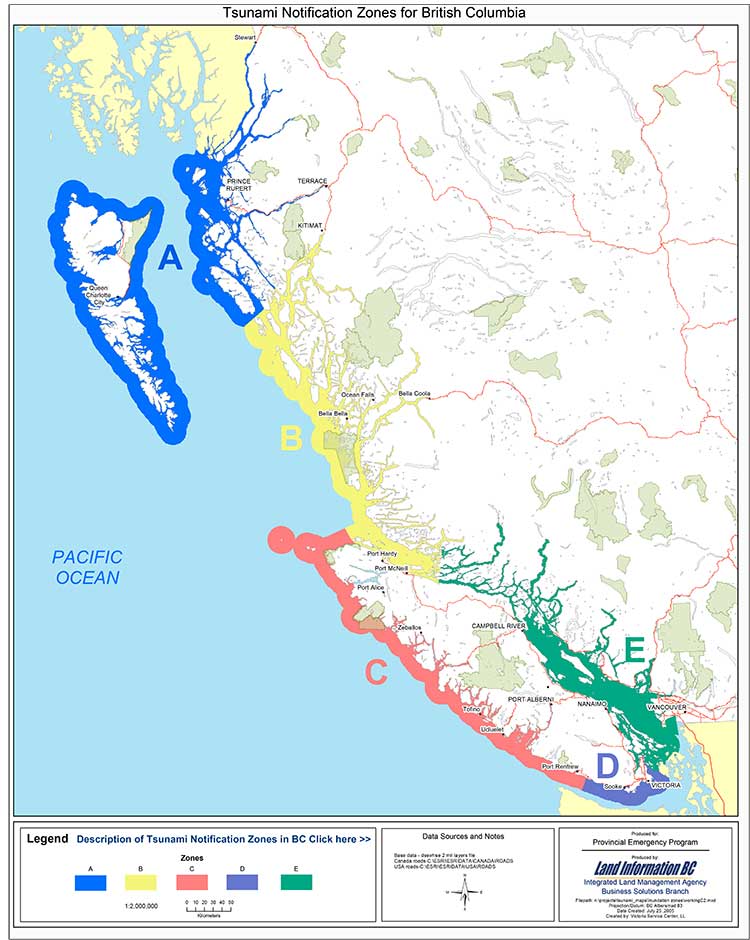
What does this mean?Tsunami warnings for zones A, B, C and D of British Columbia coast.
It would appear there is no treat to Hawaii.
BULLETIN
TSUNAMI MESSAGE NUMBER 3
NWS PACIFIC TSUNAMI WARNING CENTER EWA BEACH HI
110 AM HST TUE JAN 23 2018
TO - EMERGENCY MANAGEMENT IN THE STATE OF HAWAII
SUBJECT - TSUNAMI WATCH CANCELLATION
THE TSUNAMI WATCH IS CANCELLED FOR THE STATE OF HAWAII EFFECTIVE
AT 0110 AM HST.
AN EARTHQUAKE HAS OCCURRED WITH THESE PRELIMINARY PARAMETERS
NOTE REVISED EARTHQUAKE MAGNITUDE
ORIGIN TIME - 1132 PM HST 22 JAN 2018
COORDINATES - 56.0 NORTH 149.2 WEST
LOCATION - GULF OF ALASKA
MAGNITUDE - 7.9 MOMENT
MEASUREMENTS OR REPORTS OF TSUNAMI WAVE ACTIVITY
GAUGE LOCATION LAT LON TIME AMPL PER
------------------- ----- ------ ----- --------------- -----
DART 46403 52.6N 156.9W 1024Z 0.03M / 0.1FT 08MIN
DART 46410 57.6N 143.8W 1008Z 0.04M / 0.1FT 06MIN
DART 46409 55.3N 148.5W 0944Z 0.12M / 0.4FT 04MIN
LAT - LATITUDE (N-NORTH, S-SOUTH)
LON - LONGITUDE (E-EAST, W-WEST)
TIME - TIME OF THE MEASUREMENT (Z IS UTC IS GREENWICH TIME)
AMPL - TSUNAMI AMPLITUDE MEASURED RELATIVE TO NORMAL SEA LEVEL.
IT IS ...NOT... CREST-TO-TROUGH WAVE HEIGHT.
VALUES ARE GIVEN IN BOTH METERS(M) AND FEET(FT).
PER - PERIOD OF TIME IN MINUTES(MIN) FROM ONE WAVE TO THE NEXT.
NOTE - DART MEASUREMENTS ARE FROM THE DEEP OCEAN AND THEY
ARE GENERALLY MUCH SMALLER THAN WOULD BE COASTAL
MEASUREMENTS AT SIMILAR LOCATIONS.
EVALUATION
BASED ON ALL AVAILABLE DATA THERE IS NO TSUNAMI THREAT TO THE
STATE OF HAWAII. THEREFORE... THE TSUNAMI WATCH FOR HAWAII IS NOW
CANCELLED.
THIS WILL BE THE FINAL MESSAGE ISSUED FOR THIS EVENT UNLESS
ADDITIONAL DATA ARE RECEIVED.
In how many hours would the tsunami hit? Sometimes I forget how lucky I am for not living in areas where tsunamis, tornados or volcanos can kill me.
Jesus. I know Alaska isn't exactly densely populated, but most of the people there live on the south coast, don't they?
Hope they get to safety.
Hope they get to safety.
If there's a tsunami, it will hit land in the next few minutes. The first hit will be Kodiak, in Alaska. Local reports say the entire town has been evacuated
Phew, they got em out
People on reddit are saying there are sirens going off and they've all been getting cell alerts + tv and radio obviously.
That's seismologists and buoys are for. The former detect the Earthquake and can figure a Tsunami's coming, the latter helps pin where it is and what size it's at.
And as the Independent's article shows, TV channels and the like will start broadcasting emergency signals.
http://www.independent.co.uk/news/w...ada-washington-alaska-oregon-bc-a8173606.html
The first tsunami observations are coming in. In Old Harbor, Alaska, waves of half a foot were detected, the tsunami centre says.
First waves were supposed to hit 15 mins ago so let's hope everyone's okayIf it happened 2 hours ago you'd think it would've hit by now.
So far so good. Hope it stays that way.
PST? Those are very late waves.
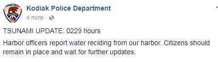
Another update from the police in Kodiak, where any tsunami would be detected first:
TSUNAMI UPDATE: 0229 hours
Harbor officers report water reciding from our harbor. Citizens should remain in place and wait for further updates.
The Kodiak PD update about water leaving the harbour is the first reliable report about the channel clearing in Alaska. But a number of other reports on social media suggest the same.
If true, that is a worrying sign: the waters move back as the wave gathers, and so a substantial amount of change in sea levels could suggest something large on its way.
Yeah, I was always taught that drawback was the first sign of an incoming Tsunami.
Hope everyone got out.
Hope everyone got out.

Also with a grain of salt but apparently some of the tsunami buoys were turned off because of the government shutdown and not turned back on yet.
Also with a grain of salt but apparently some of the tsunami buoys were turned off because of the government shutdown and not turned back on yet.
I highly doubt that was the case, they're automated aren't they?