• Ever wanted an RSS feed of all your favorite gaming news sites? Go check out our new Gaming Headlines feed! Read more about it here.
Oct 25, 2017
4,553
Does look like Bermude is going to take a blow from this thing though

Imagine being a tiny island and this thing making a sharp right turn to almost full bore slam right into you
 

pulsemyne

Member
Oct 30, 2017
2,635
Latest runs show humberto becoming a pretty potent hurricane with 80 hours.
GFS
gfs_mslp_uv850_09L_14.png


HMON goes for something enormous
hmon_mslp_uv850_09L_29.png
 
Nov 7, 2017
2,602
First advisory for Tropical Depression 10:


SUMMARY OF 1100 AM AST...1500 UTC...INFORMATION
-----------------------------------------------
LOCATION...12.9N 44.9W
ABOUT 1165 MI...1870 KM ESE OF THE LEEWARD ISLANDS
MAXIMUM SUSTAINED WINDS...35 MPH...55 KM/H
PRESENT MOVEMENT...WNW OR 295 DEGREES AT 12 MPH...19 KM/H
MINIMUM CENTRAL PRESSURE...1007 MB...29.74 INCHES


WATCHES AND WARNINGS
--------------------
There are no coastal watches or warnings in effect.

Interests in the Northern Leeward Islands should monitor the
progress of this system.


DISCUSSION AND OUTLOOK
----------------------
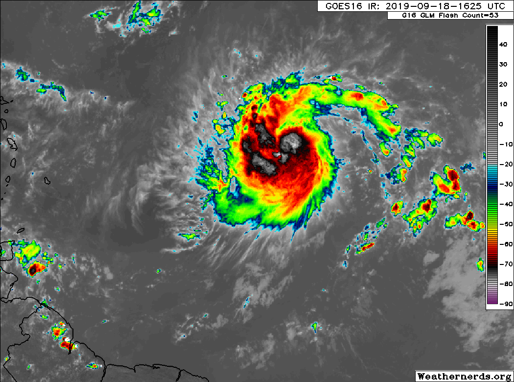
At 1100 AM AST (1500 UTC), the center of Tropical Depression Ten was
located near latitude 12.9 North, longitude 44.9 West. The
depression is moving toward the west-northwest near 12 mph (19
km/h). A west-northwestward motion at a somewhat faster forward
speed is expected over the next few days. On the forecast track,
the system will approach the northern Leeward Islands Thursday night
or Friday.

Maximum sustained winds are near 35 mph (55 km/h) with higher gusts.
Strengthening is forecast during the next couple of days, and the
depression is expected to become a tropical storm later today. The
system is forecast become a hurricane by the time it approaches the
northern Leeward Island.

The estimated minimum central pressure is 1007 mb (29.74 inches).

144756_5day_cone_no_line_and_wind.png
 

Solidsnakejej

Member
Oct 25, 2017
13,761
Fort Lauderdale
In Nola, our retired weatherman Bob Breck swears there some fuckery going on in the western part of the Gulf that may develop.

Edit: And I just sanity checked NHC site and they are showing it as of an hour ago:


Yea its a system that is being watched, won't develop into more then a TS, it will bring a lot of rain and possible flash floods to the coast of Texas

Also note with this image, rainfall can be more/less, its mainly to give a sense of where its going to fall.
L4yLKQq.gif
 
Last edited:

Solidsnakejej

Member
Oct 25, 2017
13,761
Fort Lauderdale
^^ yep, 40 MPH winds,

LOCATION...28.9N 95.3W
ABOUT 0 MI...0 KM S OF FREEPORT TEXAS
ABOUT 40 MI...65 KM SW OF GALVESTON TEXAS
MAXIMUM SUSTAINED WINDS...40 MPH...65 KM/H
PRESENT MOVEMENT...N OR 5 DEGREES AT 7 MPH...11 KM/H
MINIMUM CENTRAL PRESSURE...1009 MB...29.80 INCHES
 

Neoxon

Spotlighting Black Excellence - Diversity Analyst
Member
Oct 25, 2017
85,287
Houston, TX
*checks thread*

Well that explains the metric fuck-ton of rain in Houston for the next week & a half.
 
OP
OP
perfectchaos007

perfectchaos007

It's Happening
Member
Oct 25, 2017
12,230
Texas
Not really, NHC and weather people have been watching for the past several days, it organized pretty rapidly last day or so. There was always a chance for a TS, OP has a constantly updating map to show areas of interests and storms
It was a little surprising that the NHC over the past few days gave it a 10%-30% chance of development, even up to just a couple hours ago. Then boom we have a named storm that's already practically over land already
 

Jmdajr

Member
Oct 25, 2017
14,534
Well I guess I won't be coming to work tomorrow. Luckily the commute rain in Houston isn't that bad.... yet.

Glad I cut my grass and turned off the sprinkler system.
 

BasilZero

Banned
Oct 25, 2017
36,343
Omni
I wonder how bad travel will be to Houston (since I commute to work there).

I am guessing close to impossible considering normal storms flood the shit out of the streets
 

Dega

Member
Oct 25, 2017
7,304
I wonder how bad travel will be to Houston (since I commute to work there).

I am guessing close to impossible considering normal storms flood the shit out of the streets
What part? If coming from brazoria county I wouldnt risk it. It's flooding here where I am in Angleton already. Supposed to rain all night and tomorrow too.
 
OP
OP
perfectchaos007

perfectchaos007

It's Happening
Member
Oct 25, 2017
12,230
Texas
Looks like the storm has stalled over the west side of Pearland. Not sure if it's gonna boogie on out of here fast like the forecast suggests.
 

Ryuelli

Member
Oct 26, 2017
15,209
Another Houstonian checking in (well, Cypress...). It's been damp here all day, but we haven't really had any bad rain yet.
 

Vestal

Attempted to circumvent ban with alt account
Banned
Oct 26, 2017
2,297
Tampa FL
We have Tropical Storm Jerry. Will be extra official in about 10min in the 11pm Advisory.

image


222953_5day_cone_with_line_and_wind.png
 

scitek

Member
Oct 27, 2017
10,054
Most models are in agreement that Jerry's going to turn out to sea. The one that I'm watching is the next wave coming off Africa.

The Euro has it as a storm in 10 days that looks like it's heading toward the US.


The GFS shows nothing.


Pwnz

Member
Oct 28, 2017
14,279
Places
Austin is barely getting any of the rain. But silver lining is that it finally knocked out that stubborn high pressure. We were getting highs of 102 every day until a few days ago. Now we are hoghs around 90 and dropping which is where we should have been.